Harnessing
the Power of
Innovative Technology
Click and drag the <> button to compare datasets.


The dataset above combined aerial, terrestrial, and mobile LiDAR to deliver a rich dataset capable of highway design.
Click and drag the <> button to compare datasets.
Harnessing
The Power of
Innovative Technology.
The dataset above combined aerial, terrestrial, and mobile lidar to deliver a rich dataset capable of design.

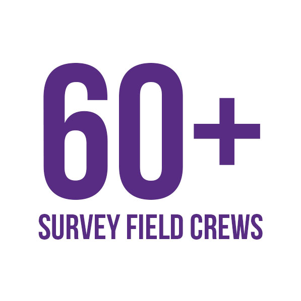

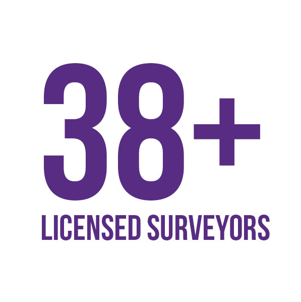
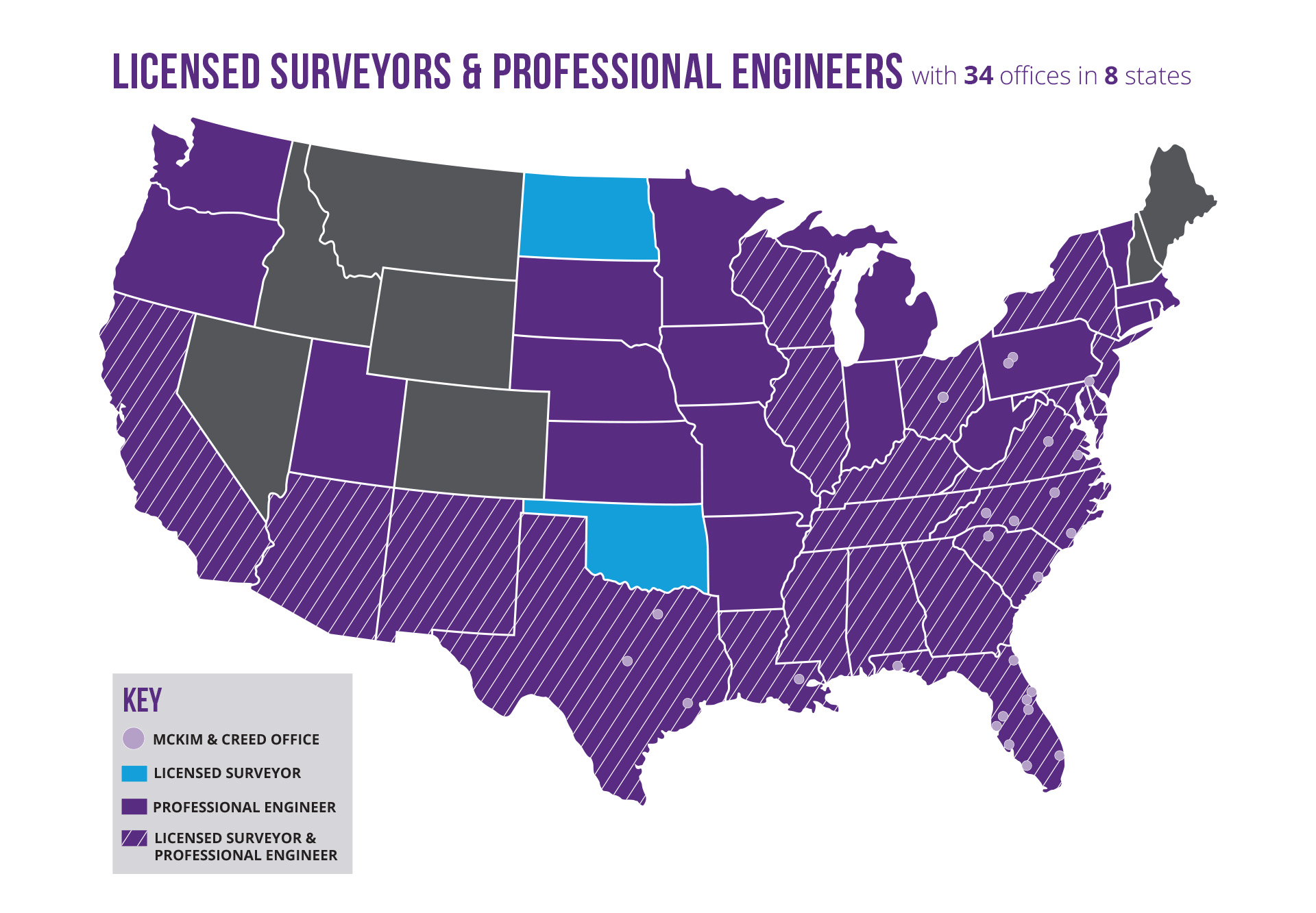
Our Geomatics Services
McKim & Creed's Geomatics team provides surveying and mapping services necessary to build, expand, and transform America’s infrastructure. Our state-of-the-art technologies enable us to provide the services municipalities and private industries need to build infrastructure.
Boundary and Topographic Surveys
Performing boundary and topographic surveys are paramount to our profession. We understand the needs of clients and know that an accurate and reliable map of the existing conditions is critical to designing future improvements. It requires special care and experience to properly weigh the field evidence alongside the historical deeds, plats, and other records to make the right call.
Terrestrial Lidar
McKim & Creed utilizes high-definition tripod-mounted lidar scanners to collect data in areas that may not be accessible through traditional survey methods. The scanners are capable of sub-centimeter accuracy point clouds, which can be used on exterior or interior building features as well as playgrounds, parking areas, and other features. The scanners are capable of collecting over 3,000,000 data points per second and can be inserted into a CAD file for design and planning purposes.
Hydrographic Surveys
Hydrographic surveyors provide the surveying and mapping tools necessary to monitor coastline erosion, measure and map navigable water bodies, monitor shorelines and beaches, provide data for hurricane recovery programs, measure depths and compute volumes for dredging projects, locate and map submerged obstructions, and prepare for underwater construction. Our team includes ACSM-certified hydrographers, USCG boat captains, and hydrographic technicians. Surveys performed by our team include single-beam sonar, multi-beam sonar, side scan sonar magnetometer, subbottom profiling and bottom grabs
Unmanned Aerial Systems
Unmanned aerial systems (UAS) allow safe, accurate, cost-effective data collection in areas that are inaccessible to conventional surveying methods. Compared with manned flights, UAS is less restricted by project size, more cost-effective, and less affected by weather conditions, yet unmanned flights achieve the same 5-cm data accuracy.
Mobile Lidar
This innovative system integrates 3D laser scanning, GPS, inertial measurement, and video technologies mounted on vehicles like SUVs, rail trucks, or survey vessels. It swiftly gathers dense 360-degree data at posted speeds. Mobile scanning technology has revolutionized how accurate pavement data is captured for design purposes because of its safety, quality, accuracy, and efficiency. MoDaC Mobile Data Collection® is McKim & Creed’s innovative mobile scanning system, which makes us one of the few firms on the East Coast and in Texas to offer turnkey mobile scanning services.
Subsurface Utility Engineering
We specialize in the accurate location of underground utilities to help engineers and contractors alike manage the inherent risks associated with underground utilities. Appropriate for any project requiring underground utility verification, SUE is ideal for municipal infrastructure; transportation; gas, electric and nuclear utilities; and land development projects. Armed with accurate utility information, designers can plan projects that minimally impact utilities while improving productivity. Using a variety of techniques and equipment, McKim & Creed’s SUE technicians can meet the needs of any size project. We provide all quality levels of SUE services
Airborne Lidar
High-density lidar technology offers clients the benefits of fast, safe and accurate data. From wide-area mapping to detailed aerial surveys for routing and design, our remote sensing teams offer a complete collection of lidar mapping technologies. Services include lidar acquisition and processing,lidar classification and feature extraction, DTM, DEMand planimetric and topographic mapping. Final products are delivered in industry-standard format, including AutoCAD, MicroStation, TopoDOT, CAiCE, PLSCADD, Esri and more.
3-D Imaging/Laser Scanning
Scanning 3-D (Phase-Based) Laser Scanning: With 3-D laser scanning, whatever your eye sees can be measured to millimeter accuracy in only minutes. These scanners quickly collect high-resolution, panoramic images of the environment and objects near the scanner. These images hold spatial information that digitizes the environment into CAD, allowing for precise measurements of even the smallest details and eliminating the need for survey crews to return to the site to collect additional data. McKim & Creed recently added the NavVis System to our 3-D Scanning technology
Emergency and Rapid Response Services
McKim & Creed is committed to providing rapid and effective emergency response services. During emergency situations such as Hurricane Hermine and Hurricane Ian in Florida and Hurricane Florence in North Carolina, McKim & Creed was able to mobilize swiftly to assess the damage, develop interim solutions, and oversee construction to minimize impacts, demonstrating a strong capability to manage crisis situations effectively. During a disaster, resources in the affected area may be unable to help, and outside resources are necessary. McKim & Creed has a vast network of trained professionals that can be mobilized when needed.
Experience
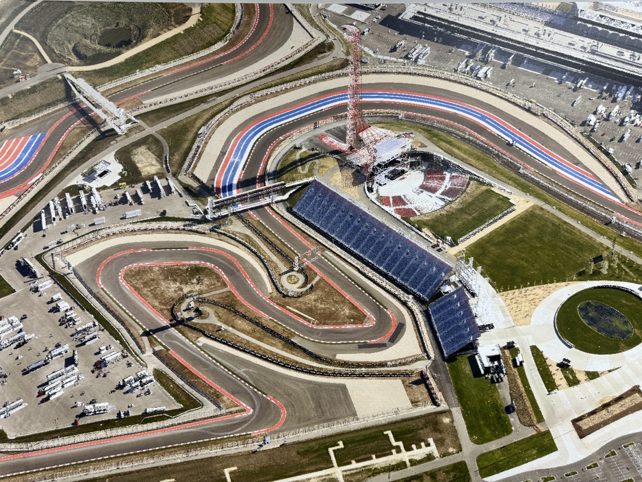
Circuit of The Americas Aerial LiDAR dataset
This Aerial LiDAR Dataset of The Circuit of The Americas Track in Austin, Texas, was captured and processed by McKim & Creed's Aerial Mapping Team.
.jpg)
Power Plant Survey
McKim & Creed provided surveying and engineering services for approximately 130 miles of natural gas transmission pipeline built to expand and convert a steam plant from coal to natural gas. McKim & Creed performed land surveying, engineering and environmental services, as well as aerial mapping of the corridor with digital orthophotos.
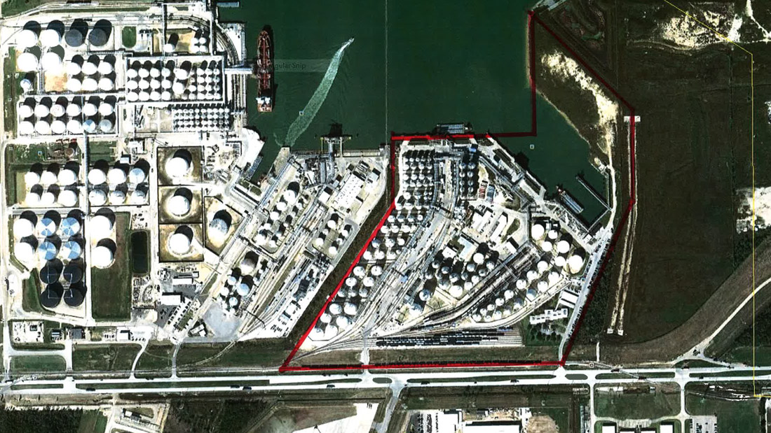
Oil & Gas Storage Facility
McKim & Creed was tasked with providing field survey support and aerial photography in support of an ALTA Land Title boundary survey for a 75-acre site at a petroleum storage facility.
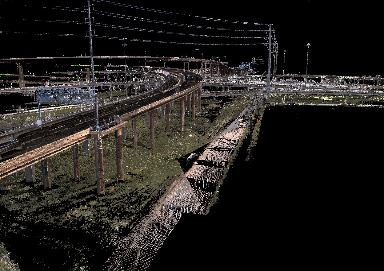
I35E & IH635 Comprehensive LiDAR for TxDOT
McKim & Creed collected and combined aerial LiDAR, mobile mapping LiDAR, terrestrial scanner LiDAR and conventional survey data from a total station with an electronic distance meter (the fourth type of LiDAR) into a homogenous set of information.

I-275 Tampa Bay Next
McKim & Creed served as prime consultant and program manager for a 5-year, $5-million contract to provide surveying and mapping services for 31 miles as well as additional projects included within the I-275 Tampa Bay Next program.
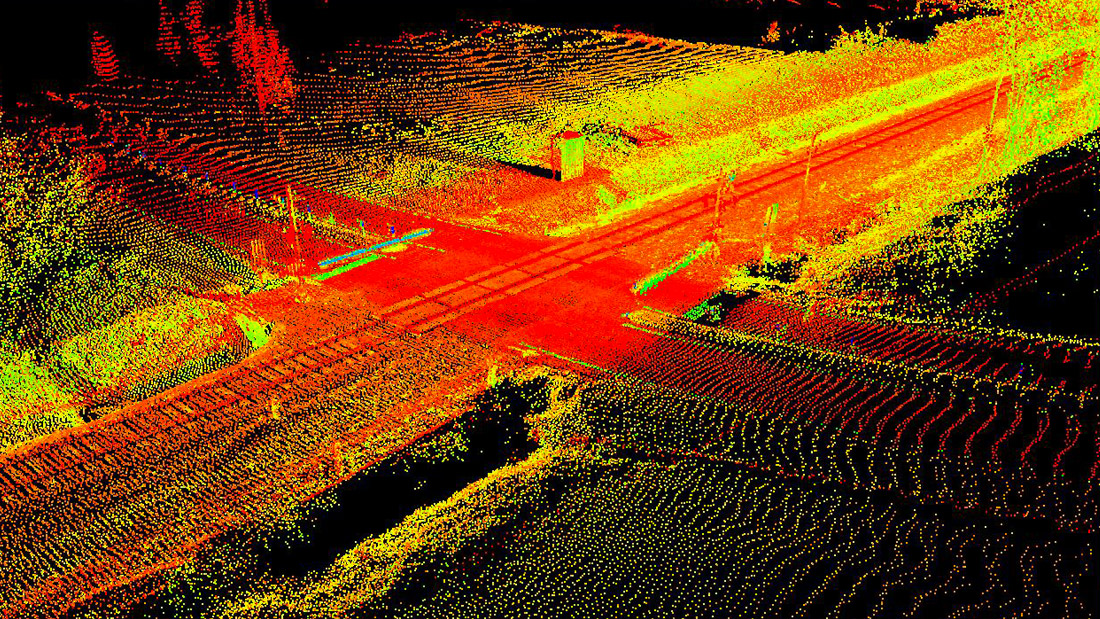
NCDOT Railroad Mobile Scanning Projects
McKim & Creed completed three mobile laser scanning projects comprising approximately 33 miles of railway line for NCDOT. Top-of-rail breaklines were extracted from the collected image data and, in addition to footage of the data collection process, were delivered to the client.

I-4 / SR535 Interchange Design Build
This project comprised a heavily traveled section of Interstate 4 and State Route 535 in Orlando, FL. McKim & Creed established secondary control and provided survey support for mobile lidar for recently repaved surfaces and high-resolution static lidar for detailed bridge surveys and geotechnical boring surveys.

SUE, Utility Coordination
for I-69
McKim & Creed furnished SUE and utility coordination for a section of one of the highest-priority corridors in the US.
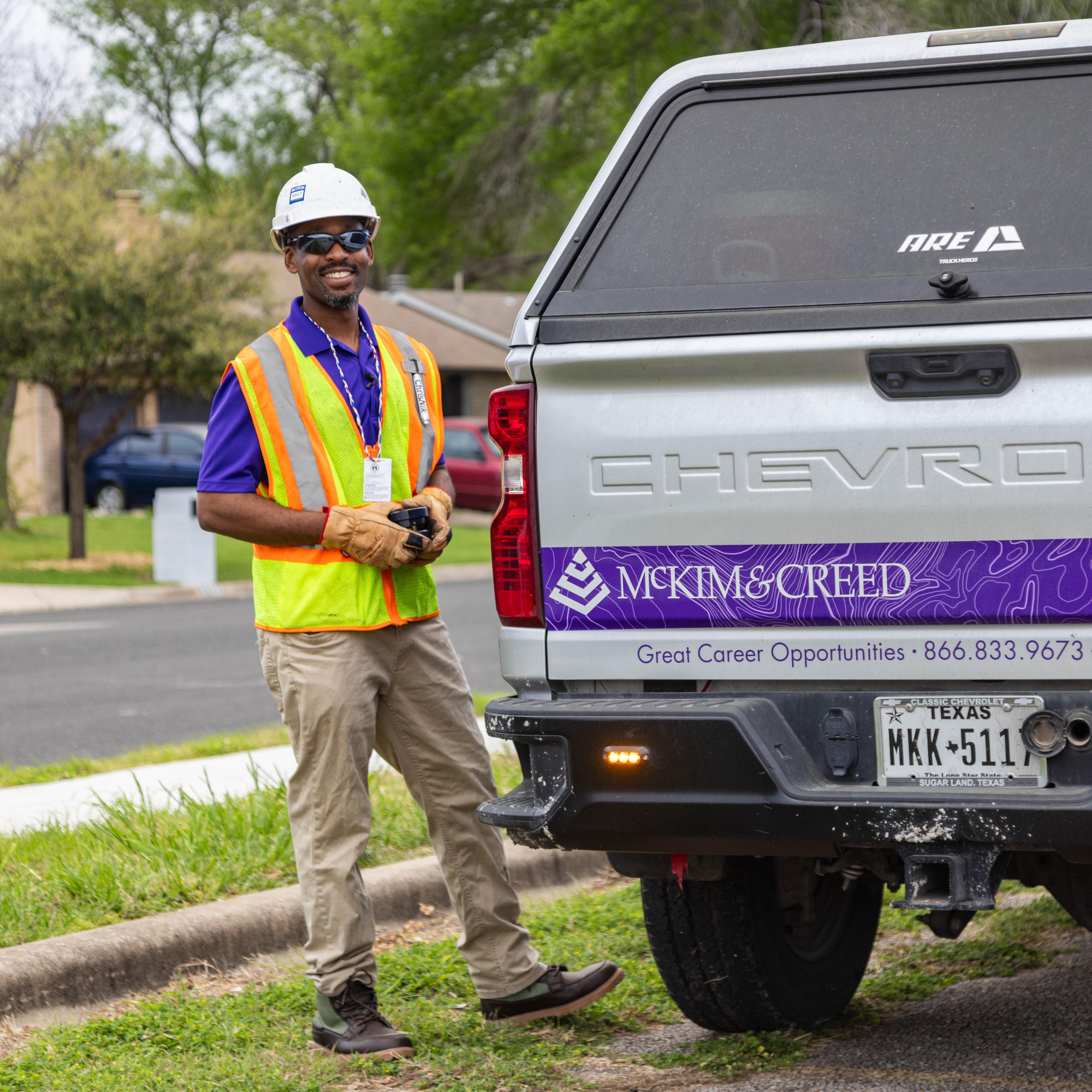
Join Our Team
Our Team is always on the look out for talented Geospatial experts!


.png)
Employee-Owned

Growth Opportunities

Advanced Technology
Contact One Of Our Experts

Matthew LaLuzerne
Business Development Director

Todd King
Business Development Director

Taylor Henninge
Director of Surveying

Trevor Tyson
Senior Mobile Mapping Project Manager

Sarah Stillman
Senior LiDAR Technician

Martin Taylor
Project Manager

Daniel Kroeze
LiDAR Technician III

Kyle Neiswender
LiDAR Technician II

Brian Saunders
LiDAR Technician II

Zach Saavedra
LiDAR Technician II

David Voorhees
LiDAR Technician I

Milton Brannan
LiDAR Technician I
Contact One Of Our Experts
Todd King, PLS, LEED AP
Business Development Director

Nick Miguez, PLS
Geomatics Regional Manager

David Lukac PLS, EIT
Survey Group Leader Greenville
Meet the experts


Bill Almes
Regional Director

Matthew LaLuzerne
National Director of BD & Geospatial Services